Ultimately, when maneuvering below minimum IFR altitudes, you need to understand what's keeping you out of the rocks.
This is the most overlooked and undertaught aspect of IFR flying.
Departure Procedure Basics
Reference: FAA Instrument Procedures Handbook, Chapter 1, Section: Departure Procedures
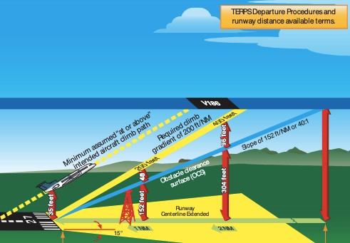
Departure procedures assume:
- You cross the departure end of a runway at or above 35’ AGL
- Climb to 400’ AGL before ANY initial turn, and
- Maintain at least 200 ft/NM climb rate until reaching minimum IFR altitude
If there are no obstacles in that zone, the airport is released for a “diverse departure” and you can safely turn any direction upon reaching 400 AGL. This is indicated by the lack of obstacle departure procedure in the takeoff minimums section:
- NOTE: The order in the takeoff minimum section is (1) takeoff minimums, (2) departure procedure, (3) takeoff obstacle notes.
- If the first two items are skipped, then diverse departure is assessed
MANY EXCEPTIONS when obstacles reach into that zone, requiring some combination of:
- Non-standard climb gradient
- Increased visiblity requirements on departure
- Obstacle departure procedure
- Diverse Vector Area
- Visual Climb Over the Airport
You can also find out exactly what drives this assessment
Where to Find
- Find the departure procedure information in the takeoff minumums section of the FAA TERPS
- On Foreflight, go to AIRPORT → Procedure → Departure → Takeoff Minimums
- In the FAA approach plates, it's in the front matter called IFR Takeoff Minimums, Departure Procedures, and Diverse Vector Area (Radar Vectors)
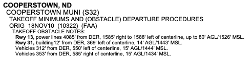
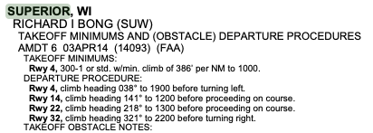
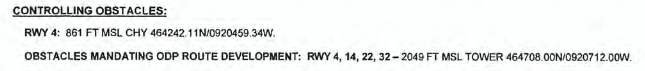
- Find the "controlling obstacles" for any airport with an instrument approach. Look here FAA Instrument Flight Procedures Information Gateway and then:
- Type the airport you want in the filter box
- Select the "IFP Documents (NDBR)" tab just beneath the filter box
- Select the Departure Procedure or Airport Name
- Read the "controlling obstacles" that are populated on the displayed pdf
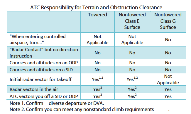
So...who is reponsible for avoiding the rocks?
Let’s always recall FAR 91.3(a): The pilot in command of an aircraft is directly responsible for, and is the final authority as to, the operation of that aircraft.
But, here’s a very good summary of varying departure scenarios.
These scenarios are discussed in detail below.
Towered Airport Departures
Assigned Heading on Departure
ATC assumes responsibility for terrain and obstacle avoidance when IFR aircraft are below the minimum IFR altitude (MVA, MIA, MEA) and issued vectors.
How can they do this? FAA JO 7110.65 (Air Traffice Control Procedures and Phraseology — Vectors Below Minimum Altitude) Section 5-6-3 allows this avoiding obstacles in the terminal area.
NOTES (from JO 7110.65 4-3-2 Departure Clearances):
- The initial heading is required to be consistent with published departure procedure (or ODP)
- or consistent with or diverse vector area requirements (look for non-std climb requirements)
- If no departure procedure published: standard takeoff minimums apply, obstacle clearance requirements are satisfied, and vectoring of IFR aircraft is permitted below the MVA/MIA. (FAA 7210.3 Facility Operations, 3-8-5 Establishing Diverse Vector Areas)
EXAMPLE: "Turn left heading 160, Runway 18 cleared for takeoff."
Climb to 400 AGL, turn to heading 160. ATC has assumed obstacle clearance.
Assigned a Published Departure Procedure
Standard Instrument Departure (SID) routing guarantees obstacle protection. (Instrument Procedures Handbook Chapter 1 Standard Instrument Departures)
NOTE: Read the SID carefully and ensure you are able to comply with all requirements that are “baked in” to keeping you clear of obstalces:
-
Procedure for turboprops or turbojets only
PDF Viewer
-
Procedure requiring an increased climb rate
PDF Viewer
-
Procedures with specific turn or crossing restrictions
PDF Viewer
Vectored off Published Path
If flying an assigned departure procedure and vectored off the route: ATC assumes responsibility for terrain and obstacle avoidance when IFR aircraft are below the minimum IFR altitude and are taken off departure procedures (7110.65 5-6-3)
Diverse Vector Area (DVA)
Reference: AIM 5-2-9-b
- DVA allows radar vectors from takeoff until reaching minimum IFR altitude during an uninterrupted climb
- Established in accordance with diverse departure criteraia
- Provides obstacle and terrain clearance in lieu of ODP or SID
- Requires increased climb gradient — see the takeoff minimums for info
Non-Towered
Big Takeaway: You are On Your Own (Potentially For a While) !
- Pilots are responsible for terrain clearance until reaching the controller’s MVA. (Instrument Flying Handbook Chapter 2)
- ODPs are recommended for obstruction clearance and may be flown without ATC clearance unless an alternate departure procedure (SID or radar vector) has been specifically assigned by ATC (AIM 5-2-9.a)
- While true, I recommend communicating such intention during the clearance readback (After the readback, state, “N172AR will fly Runway 2 ODP until reaching 2200 feet, then proceed on assigned heading 260…”)
- Obstacle clearance responsibility rests with the pilot when he/she chooses to depart IFR under 14 CFR part 91 and has not filed or been cleared for an ODP or an ATC-assigned SID or assigned headings for a DVA from the departure runway. (AIM 5-2-9.f)
- As is always the case, when used by the controller during departure, the term “radar contact” should not be interpreted as relieving pilots of their responsibility to maintain appropriate terrain and obstruction clearance, which may include flying the obstacle DP. (AIM 5-2-9.f) (in other words, “radar contact” alone does NOT imply any obstacle protection)
Types of Clearances from Uncontrolled Field
- SID: When assigned in IFR clearance, fly the SID and comply with all notes → you have obstacle clearance
- Example (from uncontrolled KPRB) “N172AR, cleared to Monterey airport via the BRALY ONE departure, then as filed…”
- ODP: If ATC assigns ODP, you must fly it → obstacle clearance provided
- Example (from uncontroleld KWVI) “N172AR, cleared to Paso Robles via the Watsonville FOUR departure, SNS, then as filed…”
- “Upon entering controlled airspace, fly heading (or proceed direct to…)” → NO obstacle clearance guaranteed
- Example: (from KSUW) “N172AR, cleared to Grand Forks airport; upon entering controlled airspace, turn left heading 260 vectors to HIB VOR then as filed…”
- If you see a ODP that conflicts with this and you can’t see the obstacles visually (at night or IMC), converse with ATC to remove any confusion. For instance, as part of your readback: “Approach, N172AR will turn 030 until 2200 feet per Runway 32 ODP and then proceed heading 260”
- “Cleared as filed (or cleared direct ABC VOR)” → NO obstacle clearance guaranteed
- Example (from KWVI) “N172AR, cleared to Half Moon Bay Airport as filed…”
- NOTE: NORCAL approach would never give you this because they know the obstacle issues here, but this is for illustration
- A direct line from KWVI to KHAF flies you into the Santa Cruz Mountains. This perfectly illustrates why the SID or ODP is required.
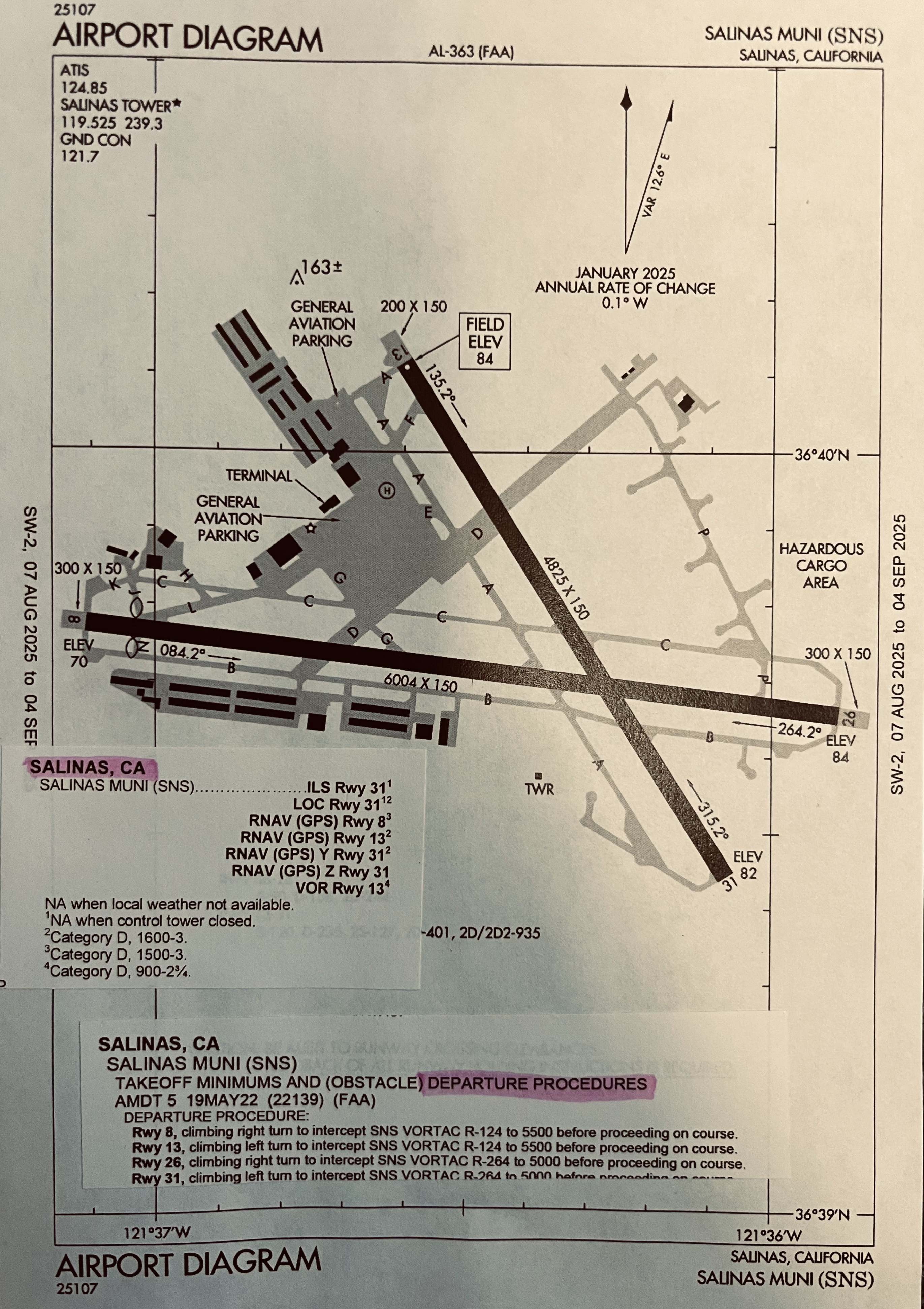
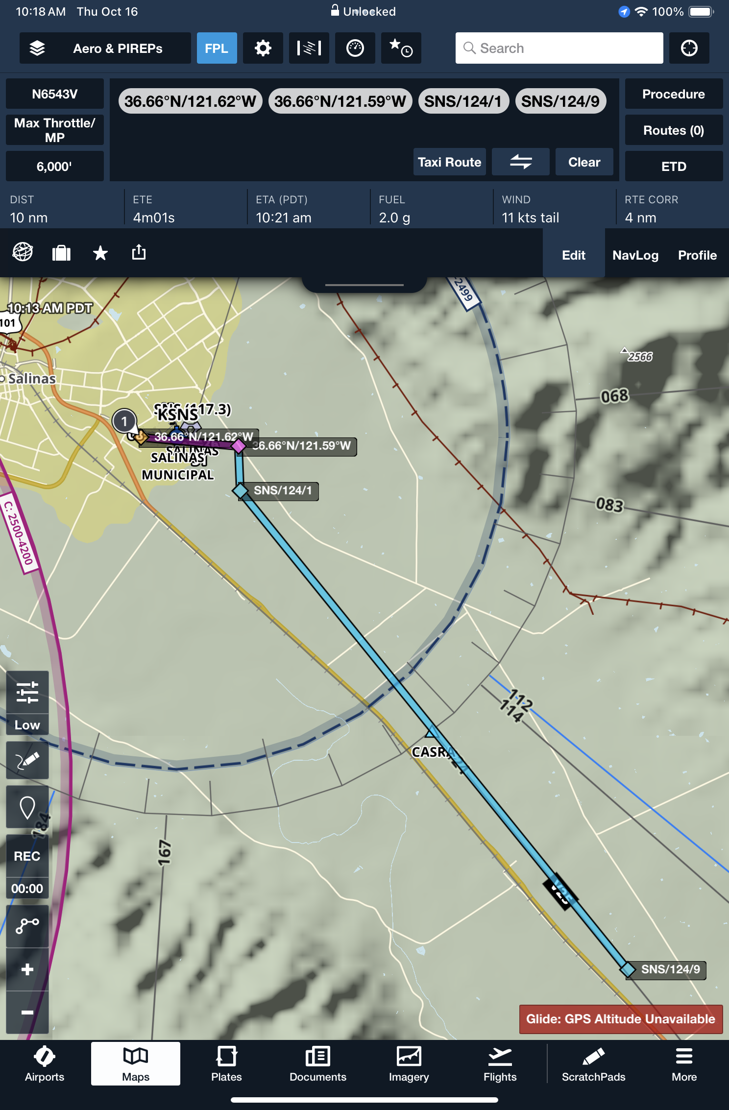
Obstacle Departure Procedure
Be familiar and know how to fly it
- I recommend actually sketching the ODP
- I recommend having a copy readily available
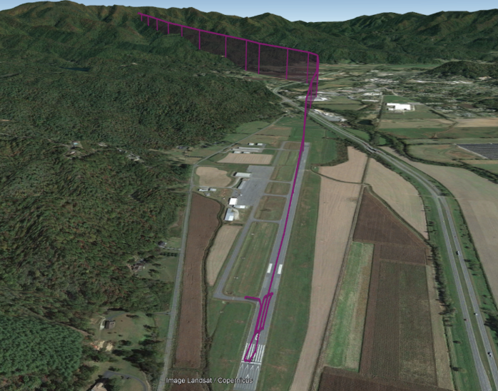
- Images below display easy-to-reference ODP and a plot on Foreflight
- You need to be a little bit creative to plot it on Foreflight, but so insightful for visualizing and executing the ODP.
- In the image below, I selected waypoints at the runway departure end, an approximate estimate of where I reach 400’ AGL, then a right turn to the required radial intercept and the estimated distance of reaching the ODP final altitude.
Vectored off the ODP
When given radar vectors off an ODP, ATC has assumed obstacle clearance responsibility.
From FAA JO 7110.65: Aircraft may not be vectored off an Obstacle Departure Procedure (ODP), or issued an altitude lower than published altitude on an ODP, until at or above the MVA/MIA, at which time the ODP is canceled. Once an aircraft has been vectored off an Obstacle Departure Procedure, the procedure is canceled and ATC cannot clear the aircraft to resume the ODP
Visual Climb Over Airfield
Reference: AIM 5-2-7.f and Instrument Procedures Handbook Chapter 1 (VCOA Section)
- This is a visual departure. Generally necessary when you can’t meet climb gradient using the ODP routing.
- Published in the ODP section with a visibility and ceiling (in AGL) requirement.
- Climb within that visibilty radius up until reaching the stated altitude.
- roceed on course in any direction climbing at least 200 ft/NM until reaching minimum IFR altitude.
ATC Coordination The AIM and the ODP state you must inform ATC of intention to perform VCOA since it is unconventional routing.
- You can put a remark in the FPL (which gives them a heads up)
- You explicitly discuss on the clearance delivery call
- Your clearance will come back like “N172AR, cleared to Anytown airport via the Departure Runway 2 obstacle departure procedure, then as filed. Remain within 3 miles of Departure Airport during visual climb. Maintain 8000. Contact NORCAL Approach on 127.15. Squawk 0531.”
Some More Detailed info
- A very good video of VCOA from Flight Insight (with clearance and explanations)
- Boldmethod explanation with lots of images and charts.

General Notes
- (Personal Opinion) The departure system is flawed in that ATC doesnt give you an explicit departure clearance at many fields and the ODPs are hard to find.
- When issued “upon entering controlled airspace…” or “cleared as filed (or direct XXX)”, without radar vectors you should be nervous: check the ODPs!!
- ATC tries to help you but MAY NOT be familiar with some airports (especially small, infrequently used airfields)
- For instance, at non-towered Watsonville (KWVI), ATC almost always assigns the ODP or SID
- Other controllers may issue your IFR clearance and recognizing an obstacle threat, do one of the following:
- State somethiing like “Verify this clearance will allow compliance with terrain or obstruction avoidance.” (FAA JO 7110.65 4-3-2 Para 3)
- In plain English, ask you about obstacle or ODP familiarity
- At remote airports served by the overlying Center controller, assume the controller knows nothing about obstacles in the area.
Determine the MVA in Your Area
Head to the FAA’s Minimum Vectoring Altitudes (TRACON facilities) or Minimum Instrument Altitudes (Center Facilites) to estimate when you can expect radar vectors.
- Download Google Earth
- Download the .kml file — the overlays will display in Google Earth
- Use your mouse to find MVAs for each sector